


Scenic Drives in Sedona: Best Red Rock Routes and Viewpoints

By: Adam Jerold Cansino | October 21, 2026
Sedona, Arizona, is one of the Southwest’s most memorable road trip destinations. Towering sandstone formations, winding canyon roads, and sweeping desert landscapes make even a short afternoon behind the wheel feel like an adventure. The best part is that many of the area’s most impressive viewpoints are accessible without a demanding hike.
From the famous Red Rock Scenic Byway to the forested bends of Oak Creek Canyon, Sedona offers several remarkable ways to appreciate its natural beauty. Some roads pass recognizable landmarks, while others reveal quiet overlooks, creekside recreation areas, and panoramic mountain views.
However, not every picturesque road is suitable for an ordinary vehicle. Major highways offer comfortable, paved sightseeing, while routes like Schnebly Hill Road require much more preparation.
This guide covers the best routes around Sedona, recommended photography stops, road conditions, and practical tips for planning an enjoyable day of sightseeing.
1. Red Rock Scenic Byway: The Classic Sedona Experience
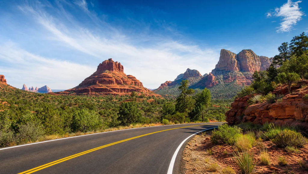
The Red Rock Scenic Byway follows approximately eight miles of State Route 179, connecting the Interstate 17 corridor with the Village of Oak Creek and Sedona.
Officially recognized as the Red Rock All-American Road, this paved highway is one of the most accessible ways to experience Arizona’s dramatic sandstone scenery.
The landscape begins opening into spectacular formations as travelers approach the Village of Oak Creek. Massive buttes rise above the desert vegetation, creating memorable views in nearly every direction.
Unlike rugged backcountry roads, this scenic byway is suitable for ordinary passenger vehicles under normal road conditions.
Best Stops Along State Route 179
Bell Rock: One of the area’s most recognizable landmarks, this bell-shaped formation dominates the eastern landscape. Designated parking areas provide access to viewpoints and walking paths.
Courthouse Butte: Near Bell Rock, this broad sandstone formation is especially impressive in early morning sunlight.
Yavapai Vista: A convenient stop for photography and appreciating the surrounding formations. Its short walking paths make it appealing for visitors who want a closer perspective.
Chapel of the Holy Cross: This remarkable architectural landmark sits among the sandstone cliffs. A separate paved road branching from State Route 179 leads to the chapel.
The byway is particularly attractive during the morning, when sunlight brings out the orange and crimson tones of the surrounding formations.
Allow approximately one to two hours if you plan to stop for photographs and enjoy the viewpoints.
2. Oak Creek Canyon: A Scenic Drive Toward Flagstaff
North of Sedona, State Route 89A travels through Oak Creek Canyon, where the landscape transitions from open desert formations to wooded canyon scenery.
The designated Sedona–Oak Creek Canyon Scenic Road covers approximately 15 miles, although travelers can continue farther toward Flagstaff.
The route winds beneath steep canyon walls, passing creekside recreation areas, forested slopes, and dramatic elevation changes.
This section offers a refreshing contrast to the area’s exposed desert surroundings. Trees and seasonal vegetation create a different atmosphere, especially in autumn, when foliage adds gold and yellow tones to the landscape.
Notable Overlooks and Roadside Stops
Midgley Bridge: A recognizable landmark near the southern canyon entrance, offering impressive perspectives across the surrounding terrain. Use designated parking rather than stopping along the bridge.
Grasshopper Point: A popular creekside recreation area where visitors can enjoy the surrounding landscape. Access may involve a day-use fee.
Slide Rock State Park: Known for its natural sandstone water features and creekside setting, this state park is a worthwhile stop for travelers who want more time outdoors.
Oak Creek Vista: Near the canyon’s northern end, this overlook offers expansive views of the winding highway and surrounding forested terrain.
The northern section includes tight switchbacks and notable elevation changes. Drivers should slow down, stay alert for cyclists, and avoid stopping outside designated parking areas.
Although the highway is paved, winter weather can occasionally create icy or snowy conditions at higher elevations.
For visitors seeking scenic drives, this canyon highway offers an unforgettable mix of rock formations, mountain scenery, and forested landscapes.
3. Red Rock Loop Road: Quiet Landscapes and Photography Stops
West of central Sedona, Red Rock Loop Road offers another rewarding sightseeing option.
The road travels through a quieter landscape of rolling hills, residential areas, and prominent sandstone formations. Unlike the busier State Route 179 corridor, portions feel more secluded and residential.
Upper and Lower Red Rock Loop roads form a popular sightseeing circuit, with opportunities to visit nearby recreation areas.
The main established driving route uses paved public roads, but travelers should not assume every connecting side road is paved or suitable for passenger vehicles.
Highlights Along the Loop
Red Rock State Park: This protected natural area features an environmental education center, walking opportunities, and landscapes surrounding Oak Creek. Entrance fees apply.
Crescent Moon Picnic Site: Located off the main loop via connecting roads, this recreation area offers picturesque views of Cathedral Rock and the creek corridor.
Cathedral Rock Views: Several locations around the loop offer distant perspectives of the dramatic formation, making the area especially appealing for photographers.
The landscape is beautiful in the late afternoon, when warm sunlight brings out the sandstone cliffs’ colors.
Visitors should respect private property and avoid entering residential driveways for photos.
Allow one to two hours for casual sightseeing, with additional time if visiting a state park or picnic area.
4. Airport Mesa Road: Panoramic Views Above the City
Airport Road climbs from State Route 89A toward the Sedona Airport, providing access to some of the area’s most popular elevated viewpoints.
This short, paved road is especially appealing for visitors who want expansive scenery without spending hours traveling between destinations.
The elevated setting reveals formations surrounding the city, including Coffee Pot Rock, Thunder Mountain, and distant sandstone ridges.
Where to Stop for the Best Views
Airport Scenic Lookout: Near the upper end of Airport Road, the established overlook provides broad views of the surrounding landscape. A parking fee may apply.
Airport Mesa Access Area: Farther down the road, a smaller parking area serves nearby walking routes and the commonly visited vortex location.
The viewpoints are separate locations, so visitors should distinguish the upper airport lookout from the lower access area.
Sunset is especially popular. However, parking spaces can fill quickly, and the roadside is not an appropriate overflow parking area.
For a quieter experience, visit in the morning.
The road is paved, but optional walking paths can be rocky and uneven.
5. Schnebly Hill Road: Rugged Backcountry Adventure
Schnebly Hill Road offers some of the most dramatic elevated scenery in the Sedona area, but it differs significantly from the paved sightseeing highways.
Also known as Forest Road 153, it climbs from the city’s eastern side toward the Mogollon Rim.
The lower approach includes pavement, but the road becomes rough and unpaved beyond the initial section.
Deep ruts, loose stones, embedded rocks, and uneven surfaces make it unsuitable for an ordinary passenger car.
What to Expect on the Unpaved Sections
The road is approximately 11 miles from the Sedona side toward its upper connection near Interstate 17.
As the elevation increases, travelers encounter increasingly impressive rock formations and panoramic views across the surrounding landscape.
One of the area’s better-known viewpoints is Merry-Go-Round Rock, a landmark known for dramatic scenery.
However, reaching this area requires navigating difficult terrain.
A high-clearance four-wheel-drive vehicle is appropriate for the rugged sections, along with a driver experienced in off-road conditions.
Visitors should never assume that an ordinary rental SUV has sufficient clearance or that its rental agreement permits unpaved backcountry driving.
Guided Off-Road Tours
For travelers without an appropriate vehicle, guided Jeep tours offer an alternative way to experience sections of the rugged backcountry.
Experienced operators provide suitable vehicles and know how to handle changing terrain.
Tour routes, schedules, and access restrictions vary, so confirm exactly which areas an operator visits before booking.
Treat Schnebly Hill Road as a separate off-road adventure rather than an ordinary sightseeing shortcut toward Flagstaff.
6. Best Overlooks for Red Rock Photography
Sedona provides numerous photography opportunities, but choosing established viewpoints makes the experience safer and more enjoyable.
Several locations stand out for their accessibility, distinctive scenery, and photographic appeal.
| Viewpoint | Main attraction | Access |
| Bell Rock Vista | Iconic sandstone formations | Paved highway and designated parking |
| Yavapai Vista | Panoramic desert landscapes | Paved access with optional walking |
| Airport Scenic Lookout | Elevated city and mountain views | Paved road and established parking |
| Oak Creek Vista | Forested canyon and winding highway | Paved State Route 89A |
| Crescent Moon Picnic Site | Cathedral Rock and creekside scenery | Paved approach and designated day-use area |
| Schnebly Hill viewpoints | High-elevation backcountry panoramas | Rough unpaved road; suitable 4WD needed |
For the best photos, consider how sunlight affects each location.
Morning light can emphasize the contours of eastern formations, while late afternoon frequently produces rich colors across west-facing cliffs.
Conditions vary with season, cloud cover, and weather, so allow extra time to capture the scenery at its best.
7. Paved Scenic Routes vs. Off-Road Roads
One of the most important considerations when planning a Sedona road trip is understanding the difference between paved highways and rugged forest roads.
A road that appears in a navigation app doesn’t automatically mean it is suitable for every vehicle.
The table below provides a general comparison.
| Road | Surface | Suitable vehicle | Difficulty |
| State Route 179 | Paved highway | Standard passenger car | Easy |
| State Route 89A through Oak Creek Canyon | Paved, winding highway | Standard passenger car in suitable conditions | Easy to moderate |
| Red Rock Loop Road | Primarily paved established circuit | Standard passenger car | Easy |
| Airport Road | Paved | Standard passenger car | Easy |
| Schnebly Hill Road beyond pavement | Rough, rocky, unpaved | High-clearance 4WD | Moderate to difficult |
| Broken Arrow off-road network | Rugged sandstone terrain | Properly equipped 4WD | Difficult |
Difficulty descriptions are general and do not replace current road assessments.
Paved routes suit visitors seeking comfortable sightseeing, family-friendly outings, and accessible photo stops.
Rugged roads suit travelers specifically seeking an off-road experience.
8. Road Conditions, Parking, and Safety Tips
Road conditions around Sedona can change throughout the year. While major paved highways are generally maintained for regular traffic, weather, construction, and visitor congestion can affect driving times.
Check Highway Conditions
Before you set out, check the Arizona Department of Transportation’s AZ511 service for current highway information.
State Route 89A through Oak Creek Canyon deserves particular attention because its switchbacks, narrow sections, and elevation changes can complicate driving during storms or maintenance work.
Construction projects may also introduce temporary lane restrictions and delays.
For forest roads, consult the Coconino National Forest for access updates and motor vehicle restrictions.
Prepare for Seasonal Weather
Spring: Generally favorable for outdoor sightseeing, although busy weekends can increase traffic and parking demand.
Summer: Warm temperatures make early morning outings more comfortable. Monsoon storms can create hazardous conditions, particularly on unpaved roads.
Autumn: Cooler weather and changing canyon foliage make this a popular season for photography.
Winter: Desert roads may remain accessible, but higher-elevation locations can experience snow, ice, and temporary closures.
Do not assume that a route is safe simply because the weather appears clear in central Sedona.
Parking and Recreation Passes
Some designated recreation parking areas require a Red Rock Pass or another accepted federal recreation pass.
Other locations, including certain state parks and privately operated recreation sites, charge separate fees.
Carry a payment method and review posted signs rather than assuming one pass covers every destination.
When parking lots are full, continue to another legal stopping area. Parking on narrow shoulders or blocking roadways creates hazards for motorists, cyclists, and emergency vehicles.
9. A One-Day Sedona Scenic Driving Itinerary
Visitors can experience several outstanding locations in one day without attempting a difficult off-road excursion.
This itinerary connects key sightseeing areas while leaving room for rest stops and photos.
Morning: State Route 179
Begin near the Village of Oak Creek and follow State Route 179 toward central Sedona.
Stop at Bell Rock Vista and Courthouse Vista to appreciate the sandstone landscape. Both locations offer excellent photography opportunities, with towering formations and expansive desert views.
Travelers who want to combine sightseeing with outdoor activities can explore nearby walking paths and hiking opportunities. The Best Hikes in Sedona: 12 Trails for Every Experience Level guide covers popular trails, including routes suitable for beginners and more experienced hikers.
If time allows, continue to Yavapai Vista or the Chapel of the Holy Cross. Morning light often creates excellent photography conditions along this corridor.
Midday: Airport Mesa and Lunch
Continue toward Airport Road for panoramic views of the surrounding landscape.
After enjoying the overlook, return to central Sedona for lunch.
This is also a convenient opportunity to explore galleries, shops, or other local attractions before continuing.
For additional itinerary ideas, see Things to Do in Sedona, AZ: 25 Red Rock Adventures and Experiences, which covers more outdoor attractions and experiences throughout the area.
Afternoon: Red Rock Loop or Oak Creek Canyon
Choose between two different landscapes depending on your interests.
Option A: Red Rock Loop Road
Head west for quieter countryside views, sandstone formations, and the option to visit Crescent Moon Picnic Site.
This is a good choice for travelers who prefer shorter drives and a relaxed sightseeing pace.
Option B: Oak Creek Canyon
Travel north along State Route 89A toward the canyon’s recreation areas and overlooks.
This alternative offers forest scenery, winding mountain roads, and a stop near Slide Rock State Park.
Visiting both alternatives in a full day can feel rushed, especially during busy periods.
Choose one for the afternoon and save the other for a separate day if your schedule allows.
10. Where to Stay for Easy Access to Scenic Routes
The right accommodation can make sightseeing easier, especially when you’re planning several days of outdoor activities.
Central Sedona provides access to restaurants, galleries, Airport Road, and nearby highways.
The Village of Oak Creek is a practical base for travelers who plan to spend substantial time around State Route 179 and its famous sandstone landmarks.
West Sedona offers access to additional residential areas, recreation opportunities, and roads leading toward the surrounding countryside.
For groups and families, a private vacation home can provide additional living space and a comfortable place to unwind after a full day of sightseeing.
Paradiso Homes offers luxury vacation rentals in Sedona, giving visitors accommodation options while exploring the area’s remarkable desert landscapes.
A longer stay also makes it easier to enjoy different viewpoints at sunrise and sunset, rather than trying to fit every destination into a single day.
Final Thoughts: Discover Sedona’s Best Views by Road
Sedona’s remarkable landscape lets you experience Arizona’s natural beauty from the comfort of a vehicle, with rewarding viewpoints along several well-established roads.
State Route 179 offers an iconic introduction to towering sandstone formations, while State Route 89A reveals the forested beauty of Oak Creek Canyon. Red Rock Loop Road provides quieter countryside scenery, and Airport Mesa rewards visitors with elevated panoramic views.
For travelers seeking a more rugged adventure, Schnebly Hill Road offers a completely different experience, but it requires the right vehicle and an understanding of the terrain.
Whether you’re organizing a short afternoon outing or planning a longer Arizona vacation, choosing the right roads, checking current conditions, and allowing time for unexpected stops can make the experience more memorable.
With thoughtful planning, Sedona offers countless opportunities to appreciate its extraordinary landscape, one scenic viewpoint at a time.
Frequently Asked Questions
What is the most beautiful road to drive in Sedona?
State Route 179, commonly called the Red Rock Scenic Byway, is an excellent choice for first-time visitors. It features iconic formations such as Bell Rock and Courthouse Butte, along with established viewpoints. State Route 89A through Oak Creek Canyon is another standout option, especially for travelers who appreciate forested canyon scenery.
Can you enjoy the scenic routes without a four-wheel-drive vehicle?
Yes. State Routes 179 and 89A, Airport Road, and the established Red Rock Loop circuit are paved and generally suitable for ordinary passenger vehicles when conditions are favorable. However, rugged forest roads, such as the unpaved section of Schnebly Hill Road, require more capable vehicles and preparation.
How long does it take to drive through Oak Creek Canyon?
A continuous trip through the designated canyon corridor may take approximately 30–45 minutes in favorable traffic, but the actual duration depends on congestion, weather, construction, and road conditions. Allow at least one to two hours if you plan to visit overlooks or recreation areas.
Is Schnebly Hill Road safe for regular cars?
Ordinary passenger vehicles can use the paved lower approach, but the rough, rocky sections beyond the pavement aren’t suitable for standard cars. We recommend a high-clearance four-wheel-drive vehicle and suitable off-road experience. Check current access restrictions before attempting the unpaved portion.
What time of day is best for sightseeing and photography?
Early morning and late afternoon generally provide attractive light and more comfortable conditions, particularly during warmer months. Popular overlooks may be crowded near sunset, so arrive earlier and allow extra time for parking to improve the experience.