


Best Hikes in Sedona: 12 Trails for Every Experience Level

By: Adam Jerold Cansino | October 15, 2026
Sedona, Arizona, is one of the Southwest’s most spectacular outdoor destinations, where towering red sandstone formations, peaceful canyons, and winding desert pathways create unforgettable hiking opportunities. Whether you’re looking for an easy family walk or a challenging climb with panoramic views, Sedona’s best hikes offer something for every experience level.
With so many options, it can be overwhelming to decide where to begin. Some routes feature steep sandstone scrambles, while others follow gentle paths through shaded forests or alongside dramatic canyon walls. Choosing the right adventure depends on your fitness level, available time, and preferred scenery.
This hiking guide compares six signature destinations: Cathedral Rock, Devil’s Bridge, Bell Rock, Boynton Canyon, Fay Canyon, and West Fork, plus six additional options worth considering. You’ll discover essential details about distance, difficulty, trailhead access, parking, and suitability to help you plan your visit.
For more outdoor adventures, scenic drives, and local experiences, explore our complete guide to Things to Do in Sedona, AZ: 25 Red Rock Adventures and Experiences.
Quick Comparison: 6 Must-Visit Sedona Hiking Trails
Before you go, compare these six destinations to find the right adventure for your schedule and experience level.
| Hiking destination | Approximate distance | Difficulty | Best for |
Cathedral Rock | 1.1–1.5 miles round trip | Strenuous | Dramatic views and scrambling |
Devil’s Bridge | 1.6–6 miles round trip, depending on access | Moderate–challenging | Natural arch photography |
Bell Rock Pathway | 3.6 miles one way; shorter sections possible | Easy–moderate | Beginners and families |
Boynton Canyon | 5–6 miles round trip | Moderate | Canyon scenery and longer walks |
Fay Canyon | 2.2 miles round trip | Easy | Casual hikers and families |
West Fork of Oak Creek | 6–6.5 miles round trip | Moderate | Shade, creek crossings, and fall foliage |
Distances are approximate and vary by starting point, turnaround location, and any connecting pathways. Bell Rock Pathway is not inherently a loop; visitors can turn around whenever they prefer.
The six destinations cover very different experiences. Bell Rock and Fay Canyon are particularly approachable, while Cathedral Rock demands more confidence on exposed stone. Devil’s Bridge rewards hikers with a distinctive natural arch, and West Fork provides a refreshing contrast to Sedona’s open desert landscape.
Cathedral Rock: A Challenging Climb With Iconic Red Rock Views
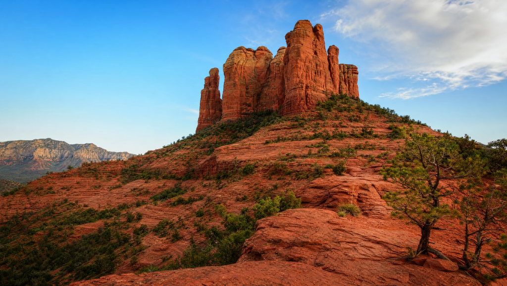
Cathedral Rock is one of Sedona’s most recognizable landmarks, drawing visitors seeking an adventure that combines physical challenge with spectacular scenery.
Although the route is relatively short, it features steep slickrock sections requiring hikers to use their hands and feet for balance. The climb becomes increasingly demanding as you approach the saddle between the towering sandstone formations.
At the top, hikers are rewarded with impressive views of surrounding red rock formations, desert vegetation, and distant mountain ridges.
Trail details:
- Distance: Approximately 1.1–1.5 miles round trip.
- Difficulty: Strenuous because of steep scrambling sections.
- Access: Back O’ Beyond Road or the Sedona Shuttle.
- Parking: The main lot closes to private vehicles during shuttle operating hours. Outside those hours, spaces are limited and applicable parking passes are required.
- Best for: Active adults, experienced hikers, and confident scramblers.
For visitors planning sunset hikes, this formation offers memorable golden-hour scenery. However, descending slickrock in low light increases the risk of slipping. Plan to finish before dark unless you’re properly prepared.
Cathedral Rock is one of the area’s most rewarding short climbs, but it is not ideal for visitors uncomfortable with heights or steep surfaces.
Devil’s Bridge: The Famous Natural Sandstone Arch
Devil’s Bridge is one of Sedona’s most popular hikes, famous for its impressive natural sandstone bridge suspended above a dramatic rocky landscape.
The journey begins with relatively gentle terrain, then steepens near the arch. Stone steps and uneven surfaces lead toward the viewpoint, where visitors can admire one of the region’s most photographed geological features.
Some hikers choose to walk onto the bridge for photos, but it’s optional. Visitors uncomfortable with exposed heights can enjoy the scenery without stepping onto it.
Trail details:
- Distance: Approximately 1.6–1.8 miles round trip from the rough-road trailhead, around 4 miles from Mescal or the direct Dry Creek Vista road approach, or nearly 6 miles via the longer Chuckwagon route.
- Difficulty: Moderate, with a steeper final ascent.
- Access: Dry Creek Road/Forest Road 152, Mescal Trailhead, or Dry Creek Vista.
- Parking: Paved access lots serve most visitors. The shortest route requires reaching a small trailhead via a rough high-clearance road.
- Best for: Adventure seekers, photographers, and hikers comfortable with uneven terrain.
Visitors researching Devils Bridge in Sedona should pay close attention to the starting location. The shortest version of the hike isn’t necessarily the most convenient for travelers driving a standard rental vehicle.
For most visitors, parking at Mescal or taking the shuttle to an appropriate access point is more practical than attempting the rough forest road.
Arrive early when possible, as the bridge attracts large crowds.
Bell Rock: One of the Best Easy Hikes for Beginners
Bell Rock is an excellent introduction to hiking in Sedona, offering striking scenery without the intense climbing required at other famous landmarks.
Located near the Village of Oak Creek, this distinctive bell-shaped formation rises above a network of paths that showcase the surrounding desert landscape.
The Bell Rock Pathway follows relatively gentle terrain, making it appealing to beginners, families, and visitors who prefer a relaxed pace. Some sections become rocky, and climbing the formation itself is a separate, much more demanding activity.
Trail details:
- Distance: About 3.6 miles one way for the full pathway, with shorter, flexible walks.
- Difficulty: Easy along most of the main pathway; more challenging on rocky offshoots.
- Access: Bell Rock Vista or Courthouse Vista along State Route 179.
- Parking: Designated lots are available and generally require a Red Rock Pass or an accepted federal recreation pass.
- Best for: First-time visitors, casual walkers, families, and photographers.
The surrounding area is also associated with Sedona’s vortex traditions, which describe certain locations as places of spiritual or emotional significance. These beliefs are part of the region’s wellness culture, not scientifically established energy phenomena.
For families traveling with kids, Bell Rock offers a convenient way to experience dramatic desert scenery without an exhausting climb.
Boynton Canyon: A Scenic Journey Through Sedona’s Wilderness
Boynton Canyon offers a different perspective on Sedona’s famous landscape, combining towering sandstone walls, wooded sections, and a gradual journey into a peaceful canyon environment.
The route begins near developed resort areas before continuing into increasingly natural surroundings. Along the way, the vegetation changes from open desert shrubs to trees and shaded sections that provide relief from direct sunlight.
The canyon’s dramatic walls make it especially appealing to visitors who prefer changing scenery over a single summit viewpoint.
Trail details:
- Distance: Approximately 5–6 miles round trip, depending on the turnaround point.
- Difficulty: Moderate.
- Access: Boynton Canyon Trailhead off Boynton Pass Road.
- Parking: A designated lot is available, but spaces can fill quickly during busy seasons.
- Best for: Intermediate hikers, nature lovers, and visitors seeking a longer canyon adventure.
The short Boynton Vista spur provides an alternative for visitors who want a scenic overlook without completing the longer canyon route.
Some visitors also seek the Subway Cave, a photogenic rock formation reached via an unofficial side route. Finding and reaching it requires extra navigation and exposed terrain, so don’t treat it as part of the standard canyon walk.
For those who enjoy quiet scenery and natural surroundings, this destination is especially rewarding.
Fay Canyon: A Relaxed Hike With Towering Sandstone Walls
Fay Canyon is an appealing choice for travelers who want impressive scenery without a demanding climb. The relatively gentle route enters a narrow canyon surrounded by high sandstone cliffs, creating a peaceful setting for a relaxed outdoor excursion.
Compared with some of Sedona’s more exposed destinations, sections of the canyon offer welcome shade from trees and rock formations.
The Fay Canyon hike is especially enjoyable for visitors interested in photography, birdwatching, or simply spending time in nature.
Trail details:
- Distance: Approximately 2.2 miles round trip along the main route.
- Difficulty: Easy, with some uneven ground.
- Access: Fay Canyon Trailhead near Boynton Pass Road.
- Parking: A small designated parking area serves the trailhead; arrive early during peak periods.
- Best for: Beginners, families, casual walkers, and visitors seeking a shorter outing.
The main path gradually leads deeper into the canyon and ends near a rocky area. Travelers who venture beyond the maintained route will encounter steeper, more difficult terrain.
Fay Canyon is a strong choice for those wanting a quieter alternative to Sedona’s busiest scenic attractions. It offers impressive red sandstone scenery without requiring a full-day commitment.
West Fork of Oak Creek: A Shaded Canyon Escape
West Fork of Oak Creek is one of the area’s most distinctive outdoor experiences. Unlike the exposed desert pathways found around many red sandstone landmarks, this route follows a wooded canyon with a flowing creek, towering cliffs, and lush seasonal vegetation.
The combination of water, greenery, and shaded canyon walls creates a refreshing change of scenery.
In autumn, the canyon becomes especially beautiful as deciduous trees turn yellow, orange, and red. In warmer months, the tree cover makes the area feel cooler than many exposed desert routes, although temperatures can still be high.
Trail details:
- Distance: Approximately 6–6.5 miles round trip for the commonly hiked maintained section.
- Difficulty: Moderate, primarily due to distance, uneven terrain, and repeated creek crossings.
- Access: Call of the Canyon Day Use Area along State Route 89A, north of Sedona.
- Parking: A separate day-use parking fee generally applies. Space is limited, especially during fall foliage season.
- Best for: Nature lovers, photographers, intermediate hikers, and travelers seeking shaded scenery.
Unlike conventional desert hiking routes, West Fork requires visitors to cross Oak Creek at multiple points. Water levels vary with rainfall and seasonal conditions, so waterproof footwear or shoes with reliable traction are useful.
Visitors should also distinguish the maintained day-hiking route from the far more demanding wilderness canyon beyond it. The Forest Service warns that travel past the established route involves substantially greater challenges.
West Fork is particularly memorable in autumn, when colorful foliage contrasts against the canyon’s sandstone walls.
Six More Scenic Trails Worth Exploring
Beyond the six featured destinations, Sedona offers many additional adventures for travelers who want to explore different parts of the region.
| Trail | Experience | Recommended for |
| Airport Mesa Loop | Elevated desert panoramas and broad vistas | Moderate hikers |
| Soldier Pass | Rock formations, sinkholes, and the Seven Sacred Pools | Intermediate hikers |
| Courthouse Butte Loop | A longer walk around striking sandstone formations | Beginners with good stamina |
| Doe Mountain | A relatively short but steep climb to mesa-top views | Moderate hikers |
| Little Horse Trail | Sweeping rock formations and access toward Chicken Point | Intermediate hikers |
| Long Canyon Trail | A quieter canyon environment with mixed desert scenery | Nature lovers |
The Soldier Pass area is best known for the Seven Sacred Pools, a series of natural depressions that can hold water after rainfall.
Airport Mesa is also a popular location for sunset views. Its elevated terrain offers wide-ranging views of the surrounding landscape, but visitors should bring lighting and plan for the descent if staying late.
Travelers who prefer a longer but less technical outdoor excursion may enjoy the Courthouse Butte area. Meanwhile, Doe Mountain rewards those comfortable climbing to a broad, elevated viewpoint.
These additional options provide variety for visitors staying several days and wanting to experience more than the region’s best-known landmarks.
Parking, Trailhead Access, and Shuttle Information
Planning transportation is essential to a successful Sedona hiking trip. Many trailhead parking areas are small, and popular routes can get crowded in spring, fall, on weekends, and during holidays.
The free Sedona Shuttle helps visitors reach several popular hiking destinations without relying entirely on limited parking.
Under the normal schedule, trailhead shuttle routes operate Thursday through Sunday, generally from 7 a.m. to 5:30 p.m., with expanded service during some busy periods.
Important access considerations include:
- Cathedral Rock: Parking at the main trailhead is closed to private vehicles while shuttle service operates. Use the North SR 179 Park & Ride and the appropriate shuttle route.
- Devil’s Bridge: Shuttle routes serve the Dry Creek Vista and Mescal access points. The rough-road approach is unsuitable for many standard rental vehicles.
- Bell Rock: Visitors can drive to designated lots along State Route 179.
- Boynton Canyon and Fay Canyon: These areas generally require private transportation or another arranged ride.
- West Fork: Access is through the Call of the Canyon Day Use Area, which charges separate parking fees.
Many Forest Service parking sites require a Red Rock Pass or an accepted federal recreation pass. However, these passes do not automatically cover concessionaire-operated day-use areas.
If you plan to explore the area by car before or after your hike, check our guide to Scenic Drives in Sedona for tips on navigating local byways and viewpoints.
For the latest access information, check the Coconino National Forest and the official shuttle schedule before leaving your accommodation.
Best Time of Year for Hiking in Sedona
Sedona offers outdoor adventures year-round, but weather conditions make some seasons more comfortable than others.
Spring (March–May): One of the best times to explore desert routes. Temperatures are generally pleasant, wildflowers may appear, and longer walks become more comfortable. Popular destinations can be crowded.
Summer (June–August): Hot daytime temperatures make exposed sandstone routes challenging and potentially dangerous. Start very early, and avoid strenuous outings during extreme heat. Monsoon storms can also create flash-flood risks.
Fall (September–November): Cooler conditions make longer canyon adventures appealing. West Fork is especially popular when the leaves change color.
Winter (December–February): Cooler temperatures can create excellent conditions for some outings, but snow and ice occasionally make steep rock surfaces hazardous.
For photography enthusiasts, sunrise often provides softer lighting and a quieter atmosphere. Sunset can transform the sandstone cliffs into brilliant shades of orange and crimson.
No matter the season, visitors should bring enough drinking water, wear supportive footwear, and check the weather forecast before starting their trip.
Choosing the Right Trail for Your Experience Level
The best choice depends on much more than distance alone.
Beginners may feel comfortable on a longer, relatively level pathway but struggle with a short route involving steep sandstone scrambling. Similarly, an experienced hiker accustomed to woodland walking may find exposed desert terrain more physically demanding than expected.
For a relaxed half-day outing, Fay Canyon and portions of Bell Rock are excellent starting points. Visitors seeking memorable photographs and more challenging terrain may prefer Devil’s Bridge or Cathedral Rock.
Boynton Canyon and West Fork are strong choices for travelers who enjoy spending several hours outdoors and watching the scenery change along the way.
Those searching for dog-friendly hikes should verify current rules before visiting. Many Forest Service routes permit leashed pets, but exposed rock, sharp surfaces, hot ground, and limited water access can create hazards. Never leave dogs unattended or let them approach wildlife.
Families should also consider whether younger children are comfortable with elevation changes, narrow paths, and uneven surfaces.
For extra planning, save an offline trail map and share your intended route with someone before you leave. Mobile coverage can be unreliable in remote canyon environments.
Where to Stay for a Sedona Hiking Vacation
Staying close to your preferred activities can make the visit more enjoyable. With popular trailheads spread across the region, a comfortable home base can cut unnecessary driving and make early starts easier.
Visitors planning several outdoor adventures may appreciate staying near West Sedona, the Village of Oak Creek, or other convenient access points.
A vacation rental can offer extra space for hiking gear, convenient meal prep, and comfortable places to relax after a full day exploring the desert.
For travelers seeking a more elevated experience, luxury vacation rentals in Sedona offer an appealing option for a nature-focused getaway.
A spacious retreat can be especially attractive for families, couples, and groups who want to combine outdoor activities with relaxation.
After a morning exploring sandstone canyons and scenic overlooks, returning to a private, comfortable space offers a welcome balance of adventure and downtime.
Final Thoughts: Discover Sedona’s Remarkable Red Rock Landscape
Sedona’s extraordinary landscape lets you experience a wide range of adventures in a relatively small area. From challenging sandstone climbs and natural arches to peaceful canyon walks and shaded creekside routes, something appeals to nearly every outdoor enthusiast.
Cathedral Rock and Devil’s Bridge deliver dramatic scenery for adventurous travelers, while Bell Rock and Fay Canyon provide approachable introductions to the desert. Boynton Canyon and West Fork reward visitors who prefer longer journeys surrounded by natural beauty.
With thoughtful planning, appropriate preparation, and a comfortable place to stay, a Sedona hiking vacation can combine exploration, memorable scenery, and relaxation in one of Arizona’s most beautiful destinations.
Frequently Asked Questions
What are the best hikes in Sedona for beginners?
Bell Rock Pathway and Fay Canyon are excellent starting points for beginners. Both offer impressive sandstone scenery without requiring difficult climbing. Bell Rock provides flexible walking distances, while Fay Canyon features a relatively short route surrounded by dramatic cliffs.
Which is more difficult: Cathedral Rock or Devil’s Bridge?
Cathedral Rock is generally more technically demanding because of its steep slickrock scrambling. Devil’s Bridge is farther from most accessible parking areas, but much of the trail is less technical. The final approach includes rocky steps and exposed areas.
Which hiking trail has the best views?
Cathedral Rock offers spectacular elevated panoramas, while Devil’s Bridge provides a distinctive natural arch and expansive desert scenery. Bell Rock is ideal for visitors who want great views without a strenuous climb. The best choice depends on whether you prefer dramatic overlooks, unusual rock formations, or accessible landscapes.
Are Sedona hiking trails suitable for families?
Many routes are family-friendly, especially shorter sections of Bell Rock Pathway and the main Fay Canyon route. More challenging destinations may not suit young children or inexperienced hikers. Families should consider terrain, weather, distance, and each child’s comfort level.
Do you need a parking pass to hike in Sedona?
Many trailhead parking areas require a Red Rock Pass or an accepted federal recreation pass. Some locations, including Call of the Canyon, charge separate day-use fees. Visitors using free trailhead shuttles generally do not need to purchase a parking pass solely for the shuttle-served trailhead.
What is the best month to visit Sedona for hiking?
April, October, and November are popular choices because temperatures are often more comfortable than during summer. October and November are particularly attractive for experiencing autumn colors along West Fork. Conditions vary each year, so travelers should check the weather forecast before visiting.
Can you complete multiple hikes in one day?
Yes. Combining two shorter outings is often practical, especially when destinations are close together. Bell Rock and a shorter scenic walk can work well together, while longer adventures such as West Fork or Boynton Canyon may be better planned as the day’s main activity.
Are the trails open year-round?
Many remain accessible year-round, but temporary closures, storms, flooding, snow, ice, wildfire restrictions, and maintenance can affect specific routes. Check official Forest Service notices and local shuttle information before departure.