


Hiking Camelback Mountain: Trail Guide, Difficulty & Best Times to Hike
By: Adam Jerold Cansino | October 1, 2026
Few outdoor experiences near Paradise Valley are as recognizable as the climb to Camelback’s summit. With its reddish rock formations, steep slopes, Sonoran Desert scenery, and broad views across the Phoenix metropolitan area, the peak offers one of the region’s most memorable outdoor challenges.
For visitors planning a Paradise Valley getaway, hiking Camelback Mountain can add a more adventurous morning to an itinerary built around resorts, dining, shopping, and relaxation. However, it’s important to understand what the climb involves before you arrive. Both primary summit routes are officially rated Extremely Difficult by the City of Phoenix, and sections require steep climbing over exposed rock.
Camelback Mountain is near Paradise Valley and Scottsdale in Phoenix, AZ, making it easy to pair with other activities in the area. Travelers building a broader itinerary can also explore the 10 Best Things to Do in Paradise Valley, AZ for a Luxury Getaway for additional ideas beyond the trail.
Camelback Mountain at a Glance
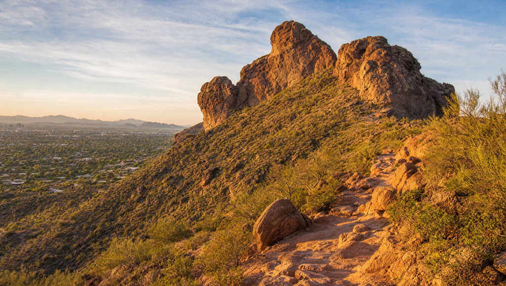
Camelback rises prominently above the surrounding city, with a summit elevation of approximately 2,704 feet. Its distinctive profile resembles a kneeling camel, which is where the landmark gets its name.
Two primary routes reach the mountain summit:
- Echo Canyon Trail: Approximately 1.14 miles each way with about 1,400 feet of elevation change.
- Cholla Trail: Approximately 1.5 miles each way with about 1,420 feet of elevation change.
- Difficulty: Both routes are officially rated Extremely Difficult.
- Trail hours: Sunrise to sunset.
- Dogs: Dogs are prohibited on all Camelback Mountain trails year-round.
The distances may appear short compared with many other hiking trails, but they can be misleading. The elevation gain is compressed into a relatively small distance, producing sustained climbing and sections where hikers may need their hands for stability.
A typical summit outing is an out-and-back experience, so remember that reaching the top is only half the round trip. Descending steep rock can sometimes require as much concentration as climbing it.
Echo Canyon vs. Cholla Trail
Visitors who want to hike Camelback generally choose between Echo Canyon on the western side and Cholla on the eastern side. Both reach the same summit, but they have somewhat different personalities.
Echo Canyon
The Echo Canyon route is the shorter of the two main options but also feels especially direct and strenuous.
It begins relatively gradually before becoming considerably steep. As elevation increases, the path turns rockier and includes sections equipped with handrails and other climbing aids. Near the upper portion, normal walking increasingly gives way to scrambling over large rocks.
The City of Phoenix describes the route as extremely difficult and notes that even prepared hikers have underestimated it and required rescue assistance. Echo Canyon may appeal to experienced hikers who prefer:
- A shorter but more concentrated climb
- Steep rocky terrain
- Hands-on rock scrambling
- A direct route toward the summit
- Easy access to restrooms and potable water at the trailhead
The official distance is approximately 1.14 miles each way, with around 1,400 feet of elevation change.
The trailhead is at 4925 E. McDonald Drive. Parking can become particularly difficult during the popular winter and spring seasons. The City of Phoenix warns that the lot can fill from late morning into the afternoon on weekdays and may remain full for much of the day on weekends.
Cholla Trail
The Cholla Trail is slightly longer, but longer doesn’t mean easier.
The lower section is generally more defined before the terrain becomes considerably more rugged toward the summit. The upper third includes large boulders, exposed sections, and challenging route finding.
Phoenix officials specifically recommend that only capable, prepared, and experienced hikers continue through the final third.
Cholla may suit hikers who prefer:
- A somewhat longer approach
- Gradual exposure to increasingly difficult terrain
- Wide desert scenery along the eastern slope
- A challenging final scramble
- A different perspective over Scottsdale and the surrounding valley
The official route is approximately 1.5 miles each way with about 1,420 feet of elevation change.
Parking near Cholla is limited. Visitors must use legal designated street-parking areas around Invergordon Road, and illegally parked vehicles may be towed.
How Difficult Is the Hike?
This is not an ordinary urban nature walk.
Both summit routes receive the City of Phoenix’s highest trail difficulty designation. The combination of rapid elevation gain, uneven rocks, exposed terrain, limited shade, and Arizona temperatures makes the experience significantly harder than mileage alone suggests.
Visitors accustomed to flatter trails may find the climb unexpectedly demanding.
Several factors contribute to the difficulty:
- Rough and uneven footing
- Sustained elevation gain
- Large rocks and boulders
- Limited opportunities for shade
- Exposed sections
- Hand-assisted climbing
- Heat and strong sunlight
- A demanding descent after reaching the summit
Echo Canyon is particularly direct, while the upper portion of Cholla becomes more technical than its lower sections.
This is one reason experienced outdoor travelers often treat Camelback as a physical climb rather than a casual sightseeing walk.
If you’re uncomfortable with scrambling, exposure, or steep descents, feel free to turn around before reaching the summit. Reaching the center of a difficult section is not a reason to continue if conditions no longer feel manageable.
Best Times for Hiking in Phoenix
Season and time of day can dramatically change the experience.
For most visitors, late fall through early spring offers the most comfortable conditions for desert hiking. Cooler temperatures make sustained climbing more manageable, although winter and spring are also among the busiest periods around the trailheads.
Early mornings are generally preferable throughout much of the year. They provide cooler temperatures and can reduce sun exposure during the most demanding portions of the climb.
Summer requires considerably more caution.
Phoenix regularly experiences triple-digit temperatures, and Camelback offers very little shade. On days when the National Weather Service issues an Extreme Heat Warning, the City of Phoenix restricts access to Echo Canyon and Cholla from 8 a.m. to 5 p.m.
That policy is designed to reduce risks to both hikers and first responders.
Fall
October and November can be excellent months as temperatures begin dropping from summer highs. Earlier starts remain useful, especially during warmer stretches.
Winter
December through February usually offers some of the most comfortable climbing conditions. The tradeoff is popularity, particularly at Echo Canyon.
Spring
March and April can bring pleasant mornings and colorful Sonoran Desert scenery. Temperatures can rise quickly later in the season, so starting early becomes increasingly important.
Summer
June through September presents the greatest heat risk. Travelers unfamiliar with desert conditions should take Phoenix heat seriously, not treat it like ordinary warm-weather travel.
Always check current forecasts, trail restrictions, and weather warnings before leaving.
Desert Hiking Safety: What to Bring
Proper hiking safety starts before you reach the trailhead.
Because the routes are relatively short, some visitors underestimate how much preparation is necessary. The combination of heat, elevation gain, exposed rock, and limited shade means hikers should arrive equipped for strenuous desert hiking.
Bring:
- Plenty of water
- Supportive shoes with good traction
- Sun protection
- A hat
- Lightweight, weather-appropriate clothing
- A charged phone
- Small snacks or electrolytes when appropriate
- A compact backpack rather than carrying items by hand
Phoenix recommends carrying ample water, staying on designated routes, dressing appropriately, monitoring weather conditions, and carrying a cell phone.
Do not wait until reaching the summit to evaluate hydration. If you have already consumed a significant amount of water during the ascent, turning around may be the safer decision.
Visitors should also watch for desert wildlife. Visitors may encounter rabbits, lizards, birds, and rattlesnakes along the routes. Saguaro, barrel cactus, prickly pear, cholla, mesquite, and palo verde are among the plants found around the preserve.
Stay on the established route rather than stepping into vegetation to pass other hikers.
What to Expect at the Summit
The physical effort is rewarded with great views across the surrounding metropolitan landscape.
From the top, hikers can look toward Paradise Valley, Scottsdale, Phoenix, and surrounding desert preserves. The contrast between rugged rock formations and the developed communities below makes the viewpoint particularly distinctive.
The summit can become crowded during popular periods, so visitors should leave room for others and avoid blocking narrow areas.
Remember that the summit marks the midpoint of the outing.
Descending through loose rock and steep scrambling sections requires controlled movement. Fatigue can make footing less precise, particularly after a difficult ascent.
Take time to rest before beginning the descent, but don’t linger so long that rising temperatures or approaching sunset become concerns.
Parking and Trailhead Planning
Transportation deserves almost as much planning as the climb itself.
At Echo Canyon, a designated parking lot serves the trailhead, but spaces are limited. During busy periods, the entrance can close when it reaches capacity, and motorists may not wait along nearby McDonald Drive or Tatum Boulevard.
Cholla has a different setup. Parking is primarily available through designated parallel parking along sections near Invergordon Road rather than a traditional trailhead lot.
Ride-share transportation can sometimes simplify logistics, especially during peak visitor periods, although hikers should still verify appropriate pickup and drop-off locations.
Since trail hours run from sunrise to sunset, plan arrival timing around the full outing, not just the ascent.
Pairing Camelback With a Paradise Valley Stay
One advantage of the location is how easily the experience fits into a broader Paradise Valley itinerary.
A challenging morning outdoors can be balanced with a slower afternoon around the pool, a spa visit, dinner, or time exploring nearby Scottsdale. The surrounding town areas also provide plenty of options for coffee, restaurants, galleries, and shopping without requiring another major outdoor excursion.
Travelers who want more space and privacy can base their trip around luxury vacation rentals in Paradise Valley, AZ. Staying nearby also makes an early trail start easier, particularly when trying to avoid heavier traffic, parking congestion, or warmer midday conditions.
Camelback works especially well as one part of a varied Paradise Valley getaway rather than the only activity of the day. Its demanding climb creates a natural contrast with the destination’s quieter side: desert views, private pools, resort-style amenities, dining, and relaxed evenings.
Final Thoughts
Camelback is one of the defining outdoor landmarks of the Phoenix area, but its accessibility should not be mistaken for simplicity.
The routes are short in mileage but demanding in elevation, exposure, and terrain. Echo Canyon offers the more direct climb, while Cholla provides a slightly longer approach before becoming considerably more challenging near the top. Both require preparation and a realistic understanding of personal fitness and comfort with steep rocky terrain.
For experienced, well-prepared visitors, the summit offers a memorable view of Paradise Valley and the wider Sonoran Desert.
Timing matters just as much as route selection. Cooler months and early starts generally create better conditions, while heat warnings and summer temperatures require additional caution. Check official trail conditions before departing, carry enough water, and be willing to turn around when conditions warrant it.
With the right preparation, a morning on Camelback can become one of the most distinctive outdoor experiences in a Paradise Valley trip.
Frequently Asked Questions
How long does it take to climb Camelback?
Time varies widely with route, fitness level, crowds, weather, and how much time you spend resting. Because both main routes gain roughly 1,400 feet over relatively short distances, visitors should plan for a strenuous outing rather than estimating time based on mileage alone.
Is Echo Canyon or Cholla easier?
Neither route is officially considered easy. The City of Phoenix rates both as Extremely Difficult. Echo Canyon is shorter and especially direct, while Cholla is longer and becomes very steep and boulder-heavy in its upper section.
Can beginners climb Camelback?
The summit routes suit capable hikers comfortable with sustained climbing, uneven rock, exposure, and scrambling. Beginners who are unsure about the conditions can explore shorter nearby options or turn around before the difficult upper sections.
What is the best month to visit Camelback?
Late fall through early spring generally offers more comfortable temperatures than summer. Winter and spring can also bring heavier visitor traffic, so starting early helps with both parking and trail conditions.
Are dogs allowed on Camelback?
No. Dogs are prohibited on all Camelback Mountain trails year-round.