


Hiking Craggy Gardens Near Asheville: A Complete Trail Guide

By: Adam Jerold Cansino | November 12, 2026
Craggy Gardens is one of the most rewarding mountain destinations near Asheville, North Carolina. Located along the Blue Ridge Parkway, this high-elevation landscape offers sweeping mountain views, twisted hardwood forests, seasonal wildflowers, and memorable trails within a relatively short drive of downtown.
For visitors seeking an Asheville hike with exceptional scenery, Craggy Pinnacle is a standout choice. The moderate route rewards walkers with panoramic views without requiring a full-day mountain adventure. Another popular option, the Gardens Trail, leads through a distinctive forest toward an open, grassy summit area.
Whether you’re planning a family outing, a photography excursion, or an afternoon exploring the Blue Ridge Mountains, this guide covers the best routes, parking locations, seasonal conditions, and important access updates following Hurricane Helene.
Craggy Gardens Hiking at a Glance
| Feature | Details |
| Location | Blue Ridge Parkway, approximately 20 miles north of Asheville |
| Main access | Mileposts 364–367 |
| Craggy Pinnacle | Approximately 1.4 miles round trip |
| Gardens Trail | Approximately 0.8 miles one way; check open segments |
| Difficulty | Moderate |
| Best scenery | Panoramic overlooks, rhododendrons, mountain ridges |
| Admission | Free |
| Recommended time | 1.5–3 hours for a scenic outing |
| Best seasons | Late spring, summer, and fall |
| Important restriction | Picnic area and some connecting trails remain closed |
The National Park Service identifies Craggy Pinnacle Trail as a 0.7-mile moderate route in one direction and the Gardens Trail as a 0.8-mile route. Always check which sections are accessible before planning your itinerary.
Craggy Pinnacle Trail: The Best Panoramic Views
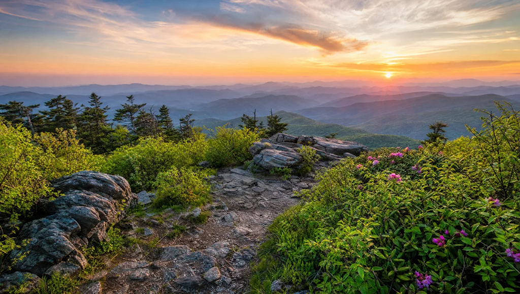
Location: Milepost 364.2, Blue Ridge Parkway
Distance: Approximately 1.4 miles round trip
Difficulty: Moderate
Best for: Couples, photographers, and visitors wanting dramatic mountain scenery
Suggested time: 45–75 minutes
Craggy Pinnacle is arguably the area’s signature attraction. The short hike begins at the Craggy Dome overlook parking lot, where a wooded path climbs steadily through an unusual high-elevation ecosystem.
The trail passes beneath twisted birch branches, dense rhododendron tunnels, and moss-covered rocks. These distinctive forests are shaped by strong winds, frequent fog, and mountain weather.
As the route approaches the summit, the surrounding vegetation becomes shorter, and glimpses of distant mountains begin appearing through the trees.
At the top, an established observation area offers sweeping views across the surrounding landscape. On clear days, visitors can appreciate the layered peaks and valleys of the southern Appalachians.
The Craggy Pinnacle Trail is especially popular because the scenery feels surprisingly expansive for its relatively modest walking distance.
Although this is not an exceptionally long route, hikers should expect uneven ground, exposed roots, and rocky sections. The elevation and sustained climb can make the ascent more demanding than its length suggests.
The parking lot can become crowded during peak foliage weekends and the June rhododendron season. Arriving earlier in the day improves the chances of finding parking and enjoying a quieter summit.
Planning tip: Stay within the designated summit viewing area. The National Park Service specifically warns that stepping beyond protective rock walls damages fragile plants.
Craggy Gardens Trail: Forests, Rhododendrons, and Open Views
Location: Visitor center area, milepost 364.6
Distance: Approximately 0.8 miles one way for the historic full route
Difficulty: Moderate
Best for: Nature lovers, wildflower enthusiasts, and relaxed sightseeing
Suggested time: 30–60 minutes for an accessible open segment
The Gardens Trail offers a different experience from the exposed summit route. Rather than focusing entirely on a dramatic overlook, it introduces visitors to the unusual vegetation and changing environments of the Great Craggy Mountains.
Starting near the visitor center, the route enters a forest with dense vegetation, twisted trees, and cooler temperatures.
The established path climbs toward a rustic trail shelter, where visitors can continue toward a beautiful open area when the relevant section is available.
During late spring and early summer, the surrounding landscape becomes especially colorful. Catawba rhododendrons produce spectacular pink and purple blooms, while other mountain wildflowers add variety along the path.
The trail also provides opportunities to appreciate distant ridges, forest textures, and the remarkable ecological conditions found at higher elevations.
This is an excellent alternative for travelers who want a nature-focused outing rather than a summit-only experience.
However, visitors should not assume the entire historic route is accessible. Hurricane Helene caused significant damage throughout portions of the Blue Ridge Parkway corridor.
According to current National Park Service information, the picnic area remains closed, along with certain connecting sections of the Mountains-to-Sea Trail. Follow posted signs and use only designated open trail segments.
The open portions of Craggy Gardens can still provide a memorable mountain experience without entering restricted areas.
Planning tip: Ask at the visitor center when staffed or consult the official NPS Craggy Gardens trail-status page before setting out.
Planning Your Blue Ridge Parkway Hiking Trip
A successful visit involves more than choosing a trail. Weather, parking, seasonal closures, and travel conditions can significantly affect the experience.
The Blue Ridge Parkway provides the primary scenic approach from Asheville, with overlooks and mountain forests along the way. Because the route follows elevated terrain, conditions can differ greatly from those in the city.
Getting There From Asheville
Craggy Gardens is approximately 20 miles north of the Blue Ridge Parkway Visitor Center in Asheville, near milepost 384.
The drive generally takes around 30 minutes from the Parkway visitor center under ordinary conditions, although traffic, weather, and construction can increase travel time.
From Asheville, drivers can reach the Parkway through the eastern side of the city and head north toward the Craggy Mountains.
Important landmarks along the route include:
- Milepost 384: Blue Ridge Parkway Visitor Center in Asheville
- Milepost 382: Folk Art Center
- Milepost 375: Ox Creek Road access
- Milepost 364.6: Craggy Gardens Trail access
- Milepost 364.2: Craggy Pinnacle trailhead
The scenic Parkway makes this outing appealing even for visitors who are not planning several hikes.
However, the Parkway is not an interstate highway. Curves, narrow shoulders, scenic pullouts, and changing visibility require attentive driving.
Download an offline map before leaving Asheville. Mobile reception can be unreliable in remote mountain areas.
Parking and Visitor Facilities
Parking is available at designated overlooks and trailheads, including the Craggy Dome parking lot serving the Pinnacle Trail.
The visitor center provides a useful starting point for checking conditions, obtaining information, and understanding the surrounding mountain environment.
However, visitor facilities operate seasonally, and hikers should not depend on all amenities being available year-round.
As of November 2026, the center operates from 10 a.m. to 4 p.m. through November 15, with winter closure beginning November 16.
Drinking water is not available at this location, so carry sufficient supplies before beginning a hike.
The Craggy Gardens picnic area remains closed following Hurricane Helene. Although travelers may encounter older guides describing picnic tables and connecting routes, those descriptions should not be interpreted as current permission to access the area.
For visitors researching places to rest along the Parkway, use designated open overlooks and approved facilities rather than entering closed recreation areas.
Before departure, consult the official Blue Ridge Parkway road-status updates.
Best Time to Visit: Spring, Summer, Fall, and Winter
The best season depends on whether visitors prioritize flowering landscapes, clear mountain views, or quieter hiking trails.
Spring and Early Summer
Late spring brings fresh foliage, wildflowers, and gradually warmer temperatures to the mountains north of Asheville.
June is particularly famous for the flowering Catawba rhododendrons that transform sections of the landscape into spectacular displays of pink and purple.
Because flowering conditions vary with weather and elevation, the exact peak cannot be guaranteed.
Nature enthusiasts may prefer exploring early in the morning, when the landscape feels peaceful and mountain fog creates atmospheric scenery.
The Parkway can also become busier during the flowering period, especially on weekends.
Summer
Summer offers longer daylight hours and generally comfortable conditions for mountain hikes.
Temperatures at high elevations are often cooler than in Asheville, making the area attractive during hot afternoons.
However, thunderstorms and sudden weather changes can occur.
Travel planners should schedule outdoor activities with sufficient flexibility and avoid exposed viewpoints during lightning.
Fall
Autumn is another excellent season for mountain photography.
The surrounding forest displays shades of orange, gold, and red, while clear weather can reveal distant ridgelines.
Fall foliage attracts significant numbers of visitors to the Parkway, particularly on weekends.
Plan your hike early, allow extra travel time, and avoid parking outside designated spaces.
Winter
Winter provides a dramatically different mountain environment, with bare trees, occasional snow, and expansive views.
However, freezing temperatures, ice, and unpredictable Parkway closures make access less reliable.
The visitor center closes seasonally, and road segments can close independently of scheduled facility operations.
A winter Asheville hike should never depend on the assumption that a mountain road or trailhead will remain accessible.
Check current NPS conditions on the day of travel.
Trail Safety, Accessibility, and Post-Helene Closures
Before heading into the mountains, prepare for changing weather, uneven terrain, and conditions that may differ substantially from those in downtown Asheville.
Both primary hiking trails are classified as moderate by the National Park Service. Their relatively short distances do not guarantee easy footing.
Visitors should wear supportive shoes and carry water, especially in warmer months.
Recommended essentials include:
- Drinking water and light snacks
- Supportive footwear with good traction
- A lightweight rain jacket or insulating layer
- Downloaded maps and a charged phone
- Sun protection and basic first-aid supplies
- A flashlight when planning late-afternoon outings
For travelers with mobility considerations, the visitor center offers accessible facilities when operating. However, this does not mean the mountain hiking trails are wheelchair accessible.
Rocky paths, roots, changing gradients, and natural surfaces may present difficulties.
Anyone requiring accessible sightseeing options should confirm current facility access rather than relying on trail distance alone.
Understanding Current Trail Restrictions
Hurricane Helene caused extensive damage across western North Carolina in September 2024, affecting roads, hiking trails, bridges, and visitor facilities.
The Parkway subsequently reopened important sections near Asheville, including access to the Craggy Pinnacle area.
Nevertheless, some restrictions continue.
As of the November 2026 NPS updates:
- Craggy Pinnacle Trail is listed as open.
- Craggy Gardens Trail is listed as open, subject to posted restrictions and the official trail-status map.
- The Craggy Gardens picnic area remains closed.
- Sections of the Mountains-to-Sea Trail between the Craggy Trail Shelter and Snowball Mountain Trail remain closed.
- The Parkway section from milepost 344.2 to 355.3 remains closed for Helene-related repairs.
Do not enter damaged areas, cross closure barriers, or attempt unofficial detours.
The National Park Service maintains current road information and a trail-status map, making those resources essential for any trip planner organizing mountain activities.
Make Craggy Gardens Part of an Asheville Mountain Getaway
A visit to Craggy Gardens fits naturally into a longer itinerary exploring western North Carolina.
Travelers can combine a morning hike with a scenic drive along the Parkway, time at an approved overlook, or an afternoon exploring Asheville’s restaurants, galleries, and cultural attractions.
For visitors interested in several outdoor experiences, the region offers different types of hikes, from forest walks and waterfall routes to higher-elevation summits.
Mount Mitchell State Park is another noteworthy mountain destination north of the Craggy area. The summit of Mount Mitchell reaches 6,684 feet, making it the highest point east of the Mississippi River.
However, access to Mount Mitchell should be planned separately, particularly when Parkway repairs affect travel routes.
Do not assume every northern section of the Parkway is accessible simply because the roads near Craggy Gardens are open.
The region also hosts seasonal events, outdoor activities, and cultural events throughout the year. Those visiting for a combination of recreation and local experiences should check individual venue schedules.
For more destination ideas, explore our guide to the 15 best things to do in Asheville, NC, which covers attractions and activities for different travel styles.
Where to Stay Near Asheville
Choosing accommodations near Asheville allows travelers to combine scenic mountain outings with dining, sightseeing, and additional outdoor adventures.
Paradiso Homes offers Asheville vacation rentals in the surrounding region, providing an alternative to conventional hotel lodging.
Depending on the property, vacation rentals may offer spacious living areas, full kitchens, mountain views, hot tubs, and room for families or groups traveling together.
For visitors planning multiple hikes, a rental home can provide a comfortable place to prepare meals, organize outdoor equipment, and relax between excursions.
The most suitable location depends on your itinerary. Properties in the greater Asheville area may have substantially different driving distances to Parkway entrances and mountain trailheads.
Before reserving lodging, compare the specific rental address with the attractions you intend to visit.
Final Thoughts
Craggy Gardens combines some of the most memorable mountain scenery in western North Carolina with manageable hiking distances and spectacular high-elevation landscapes.
The Pinnacle Trail provides an excellent introduction to panoramic Appalachian views, while the Gardens Trail highlights the region’s distinctive forests and seasonal blooms.
For the best experience, plan around current Parkway access, pack for changing weather, and leave enough time to appreciate the surrounding mountain environment.
Whether visiting Asheville for a weekend escape or spending several days exploring the Blue Ridge Mountains, this scenic destination deserves a place on your itinerary.
Frequently Asked Questions
How long does it take to hike Craggy Pinnacle?
The route is approximately 1.4 miles round trip, and many visitors complete it in about 45–75 minutes, including time for photographs.
The actual duration depends on fitness, weather, trail conditions, and how long you spend enjoying the summit.
Is Craggy Gardens suitable for beginners?
Yes, some visitors with limited hiking experience can enjoy the shorter routes, provided they are comfortable with moderate climbs, rocky surfaces, and uneven ground.
The Pinnacle Trail is a popular introduction to high-elevation hiking, but visitors should still wear appropriate footwear and assess their physical abilities.
Are the Craggy Gardens trails open after Hurricane Helene?
The National Park Service currently lists the two main trails as open, but some connecting sections remain restricted.
The picnic area also remains closed. Visitors should check the official trail map and posted signs before leaving the parking areas.
Is there an entrance fee?
No. Visiting the Blue Ridge Parkway and its designated public hiking areas does not require an entrance fee.
There may be separate charges for attractions, accommodations, or activities elsewhere in the region.
Can you see the mountains without completing a long hike?
Yes. The area provides scenic roadside viewpoints and relatively short walking opportunities.
Craggy Pinnacle offers especially impressive views for a moderate-distance route, although visitors must climb to reach the summit.
What is the best month to see rhododendrons?
June is generally considered the best month to experience the famous Catawba rhododendron displays.
However, blooming dates depend on seasonal weather, elevation, and local growing conditions.
Are dogs allowed on the trails?
Dogs are generally permitted on Blue Ridge Parkway trails when kept on a leash no longer than six feet.
Owners should keep pets under control, clean up waste, and observe posted restrictions.
Can you visit Craggy Gardens in winter?
Winter visits are possible when the relevant Parkway sections remain open, and conditions are safe.
However, snow, ice, strong winds, and seasonal facility closures can limit access. Always verify road status before traveling from Asheville.