


Best Hiking Trails Near Asheville, NC: 10 Scenic Hikes

By: Adam Jerold Cansino | November 10, 2026
Asheville is surrounded by some of North Carolina’s most beautiful mountain landscapes. From short forest walks and cascading waterfalls to panoramic overlooks and challenging summit climbs, the region offers outdoor adventures for nearly every experience level.
Some of the most rewarding trails include Craggy Pinnacle for sweeping mountain views, Moore Cove Falls for an easy waterfall walk, Black Balsam Knob for open ridgelines, and Looking Glass Rock for an adventurous climb.
Whether you’re planning a family vacation, a romantic mountain escape, or a weekend exploring the outdoors, these 10 trails offer memorable ways to experience the Southern Appalachian Mountains.
This guide compares trail distances, difficulty levels, scenic highlights, and access information. It also covers important conditions following Hurricane Helene, helping visitors choose suitable routes before setting out.
Outdoor adventures are just one part of the area’s appeal. The 15 best things to do in Asheville, NC guide also includes historic attractions, gardens, scenic drives, restaurants, and cultural experiences that complement a mountain getaway.
10 Scenic Trails Near Asheville
The mountains surrounding Asheville offer everything from gentle woodland paths to strenuous climbs. Some routes are accessible directly from the Blue Ridge Parkway, while others require a drive into Pisgah National Forest, DuPont State Recreational Forest, or nearby mountain communities.
The table below compares 10 popular routes based on distance, difficulty, and scenery.
| Trail | Approximate distance | Difficulty | Best for |
| Craggy Pinnacle | 1.4 miles round trip | Moderate | Panoramic mountain views |
| Rattlesnake Lodge | 1 mile round trip | Moderate | History and forest scenery |
| Carolina Mountain Trail | 1.2-mile trail | Moderate | Nature and family outings |
| Moore Cove Falls | 1.4 miles round trip | Easy | Waterfalls and beginners |
| High Falls and Triple Falls | About 3 miles, route-dependent | Easy to moderate | Multiple waterfalls |
| Graveyard Fields | 2.3-mile main loop | Moderate | Highland streams and scenery |
| Black Balsam Knob | About 2 miles round trip | Moderate | Open mountain ridges |
| Devil’s Courthouse | About 1 mile round trip | Moderate to strenuous | Short summit climb |
| Looking Glass Rock | 6.4 miles round trip | Strenuous | Experienced hikers |
| Hickory Nut Falls | 1.4 miles round trip | Moderate | Waterfall views and day trips |
Distances are approximate. Additional connecting paths, waterfall spurs, and alternate trailheads may change the total mileage. Always check the official map and current access restrictions before starting.
1. Craggy Pinnacle Trail: Panoramic Mountain Views
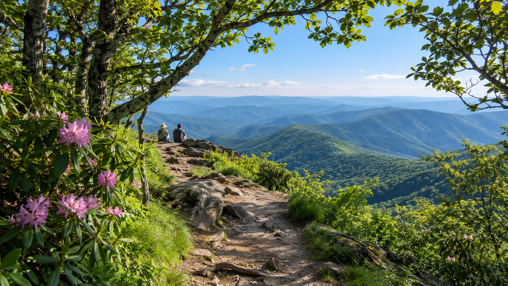
Location: Craggy Gardens area, milepost 364.2
Distance: Approximately 1.4 miles round trip
Difficulty: Moderate
Best for: Couples, photographers, and first-time mountain visitors
Craggy Pinnacle is one of the most rewarding short walks in the mountains north of Asheville.
The trail begins in a shaded forest filled with hardwood trees, rhododendrons, and distinctive twisting branches. As the path climbs, the landscape gradually opens to reveal dramatic views of the surrounding mountain ridges.
At the summit, an established overlook provides a sweeping panorama of the Southern Appalachian Mountains. On clear days, visitors can see overlapping peaks stretching across the horizon.
The scenery changes throughout the year. Late spring and early summer bring blooming rhododendrons, while autumn transforms the surrounding slopes into shades of red, orange, and gold.
Although the route is short, exposed roots, rocks, and a steady climb make supportive footwear important. Conditions can also feel noticeably cooler at the summit than in downtown Asheville.
Craggy Pinnacle is especially appealing for visitors who want impressive views without committing to a strenuous, all-day adventure.
Planning tip: The National Park Service lists Craggy Pinnacle Trail as open. However, nearby facilities and connecting routes may have separate restrictions. Craggy Gardens Picnic Area and certain Mountains-to-Sea Trail sections remain closed following Hurricane Helene, so check the specific route before visiting.
2. Rattlesnake Lodge Trail: Historical Hikes Near Asheville
Location: Near milepost 374.4, north of the city
Distance: Approximately 1 mile round trip from the NPS trailhead
Difficulty: Moderate
Best for: History enthusiasts, couples, and quiet woodland walks
Rattlesnake Lodge combines forest scenery with a fascinating piece of western North Carolina history.
The route leads to the remains of a former summer retreat owned by Dr. Chase P. Ambler, an Asheville physician and conservation advocate.
The original property included a mountain lodge and several smaller structures. Although the main building was destroyed by fire in 1920, portions of its stone foundations remain visible today.
Visitors follow a woodland path through native vegetation before reaching the historic site.
The surroundings feel different from exposed mountain overlooks. Instead of broad summit views, the appeal comes from shaded forest, historical ruins, and the peaceful atmosphere of the mountains.
The trail climbs steadily in places, making it a satisfying shorter outing for visitors who enjoy exploring local heritage.
The historic setting also provides an opportunity to learn about the development of mountain retreats in the early twentieth century.
Planning tip: The National Park Service describes the primary approach from the Parkway trailhead as approximately half a mile each way. Longer routes from alternative access points may be available, but visitors should confirm their chosen map and access conditions before following them.
3. Carolina Mountain Trail: Nature Walk for Kids
Location: North Carolina Arboretum, south of the city
Distance: 1.2-mile trail; return distance varies
Difficulty: Moderate
Best for: Families, nature lovers, and shorter outdoor outings
The Carolina Mountain Trail offers a peaceful introduction to the natural environments surrounding Asheville.
Located within the North Carolina Arboretum, the route passes through several distinct forest communities, including pine forests, mixed hardwood stands, and areas with native shrubs.
Interpretive features help visitors understand the plants, insects, and ecological relationships that shape the mountain landscape.
Along the trail, walkers encounter views of Bent Creek and the gentle cascades of Wolf Branch.
Unlike more remote mountain routes, this destination allows visitors to combine a forest experience with the arboretum’s cultivated gardens and educational attractions.
The shaded surroundings make it particularly appealing during warmer months.
Families looking for an easier alternative can explore the Natural Garden Trail, a gently graded route of approximately 0.75 miles.
The arboretum’s wider network also connects with surrounding Bent Creek recreation areas, offering additional opportunities for those who want a longer outing.
Planning tip: Carolina Mountain Trail connects several locations within the arboretum rather than forming a simple 1.2-mile round-trip route. Check the grounds map to plan your return. Vehicle parking fees generally apply, and hours may change seasonally.
4. Moore Cove Falls Trail: Easy Waterfall Walk in NC
Location: Pisgah National Forest, near Brevard
Distance: Approximately 1.4 miles round trip
Difficulty: Easy
Best for: Beginners, families, and waterfall photography
Moore Cove Falls is an excellent option for visitors seeking a scenic waterfall without a demanding mountain climb.
The trail follows a forested route through rhododendrons, native vegetation, and small streams. Footbridges and improved sections of the pathway help visitors navigate the woodland terrain.
At the end of the trail, water descends from a distinctive rock overhang into the forest below.
The waterfall is especially attractive after rainfall, when its flow can become more pronounced. During drier periods, the surrounding rock formations and woodland remain interesting features.
The relatively short distance makes this destination suitable for many casual walkers and families.
However, visitors should still prepare for exposed roots, uneven ground, and potentially slippery surfaces.
The most scenic and safest waterfall views are available from the designated observation area.
Moore Cove Falls also works well as part of a broader day exploring the Pisgah region, with additional waterfalls, forest roads, and natural attractions nearby.
Planning tip: The route is listed as open in post-hurricane visitor updates, but conditions may change after heavy rainfall. Avoid climbing wet rocks or walking behind the waterfall, where slippery surfaces create additional hazards.
5. High Falls and Triple Falls: DuPont State Forest Waterfalls
Location: DuPont State Recreational Forest, near Brevard
Distance: Approximately 3 miles, depending on the selected circuit
Difficulty: Easy to moderate
Best for: Waterfall enthusiasts, couples, and scenic family adventures
DuPont State Forest is one of the region’s most impressive destinations for waterfall scenery.
Its interconnected paths provide access to several dramatic cascades along the Little River, including High Falls and Triple Falls.
High Falls descends across a wide granite surface, creating a powerful waterfall surrounded by woodland.
Designated viewpoints allow visitors to appreciate its size and character without approaching the dangerous rock surfaces.
Triple Falls features three separate cascades that create a series of waterfalls along the river.
The surrounding forest becomes particularly attractive during spring, when vegetation turns green, and autumn, when colorful foliage frames the water.
Visitors can choose a shorter route focused on High Falls or combine multiple established paths for a longer outdoor experience.
The destination is popular with photographers because the waterfalls have different shapes, viewing angles, and seasonal appearances.
Planning tip: The Triple Falls stairs remain closed due to storm damage. The waterfall can still be enjoyed from permitted viewpoints. Temporary maintenance near the High Falls kiosk is scheduled for November 6, 2026, with November 10 designated as a possible rain date. During that work, visitors should follow the posted detour via Buck Forest Road.
Check the official DuPont State Recreational Forest closure information before departure.
6. Graveyard Fields: High-Elevation Hiking Destinations
Location: Parkway milepost 418.8
Distance: Approximately 2.3 miles for the main loop
Difficulty: Moderate
Best for: Highland scenery, streams, and seasonal foliage
Graveyard Fields offers one of the more distinctive landscapes in the mountains surrounding Asheville.
Unlike trails that remain beneath a continuous forest canopy, this area features open highland vegetation, mountain streams, and expansive views of nearby peaks.
The unusual name comes from an earlier landscape filled with tree stumps that resembled gravestones.
Today, visitors encounter low-growing vegetation, recovering forest, and flowing water.
The main loop follows established paths through the valley, with additional routes leading toward waterfalls.
Sections include boardwalks, steps, and natural surfaces. Depending on recent weather, some areas can become muddy or uneven.
The high elevation makes this destination attractive during warmer months, when temperatures may feel cooler than in lower valleys.
Autumn is particularly popular because the surrounding vegetation often develops vivid colors.
Visitors looking for a longer experience can investigate the waterfall spur routes, but these add mileage and may require more careful navigation.
Planning tip: The National Park Service lists Graveyard Fields Loop Trail as open. The basic loop is approximately 2.3 miles, and additional waterfall routes increase the total distance. Check the trail map and confirm road access before departing.
7. Black Balsam Knob: Open Ridgeline Views
Location: Pisgah National Forest, near milepost 420.2
Distance: Approximately 2 miles round trip
Difficulty: Moderate
Best for: Photographers, couples, and mountain panoramas
Black Balsam Knob stands out for its open, grassy mountain slopes and sweeping high-elevation scenery.
Rather than following a route through dense forest throughout the entire climb, visitors emerge onto exposed ridgelines with expansive views.
The journey commonly follows a section of the Art Loeb Trail, which climbs through wooded terrain before reaching the open mountain landscape.
Once above the trees, the surrounding peaks stretch across the horizon.
The unusual scenery makes this one of the area’s most popular locations for landscape photography.
The exposed terrain is especially memorable during clear mornings, when distant ridges appear layered against the sky.
However, the open summit also means visitors have limited shelter from wind, strong sunlight, and sudden weather changes.
Even during summer, conditions can be cooler than expected.
Suitable footwear, water, and an extra layer of clothing help make the experience more comfortable.
Planning tip: Access is commonly reached through Forest Service Road 816. Confirm that both the connecting Parkway section and forest road are accessible before traveling. Strong winds, lightning, and low visibility are significant concerns on exposed summits.
8. Devil’s Courthouse Trail: Short, Steep Hikes
Location: Parkway milepost 422.4
Distance: Approximately 1 mile round trip
Difficulty: Moderate to strenuous
Best for: Panoramic overlooks and short summit adventures
Devil’s Courthouse offers dramatic mountain scenery despite its relatively short distance.
Beginning near a roadside parking area, the route climbs toward a rocky overlook high above the surrounding landscape.
The first portion follows a paved path before transitioning into steeper natural terrain and steps.
Although the total distance is modest, the sustained incline can feel challenging.
At the summit, the established observation area provides impressive views across the Southern Appalachian Mountains.
On clear days, visitors may see distant landscapes extending into neighboring states.
The surrounding forest also provides habitat for plants and wildlife adapted to cooler mountain environments.
The rocky summit and exposed terrain create excellent photography opportunities, but visitors must remain behind established barriers.
This route is particularly attractive for travelers who want a memorable summit experience without spending most of the day on the trail.
Planning tip: The route is listed as open, but the connecting road may close during winter weather. The summit’s protected habitat is sensitive to visitor impacts, so stay on the maintained path and inside the designated observation area.
9. Looking Glass Rock Trail: A Challenging Summit
Location: Pisgah National Forest, near Brevard
Distance: Approximately 6.4 miles round trip
Difficulty: Strenuous
Best for: Experienced hikers and challenging mountain adventures
Looking Glass Rock is one of western North Carolina’s most recognizable natural landmarks.
The massive granite formation rises above the surrounding forest, creating an imposing mountain landscape.
The trail climbs steadily through wooded terrain, using switchbacks to gain elevation toward the summit.
Compared with shorter routes around Asheville, this outing requires significantly more time and physical effort.
The ascent involves approximately 1,650 feet of elevation gain, along with exposed roots, uneven terrain, and sustained uphill sections.
As visitors approach the upper slopes, the landscape opens to reveal views across the surrounding valleys and mountains.
The combination of dense forest and dramatic granite scenery makes Looking Glass Rock an appealing choice for more experienced outdoor enthusiasts.
However, the exposed rock areas can become extremely dangerous during wet or icy conditions.
Hikers should remain on established routes and avoid approaching steep edges.
The full trip may require several hours, depending on fitness, trail conditions, and time spent resting.
Planning tip: Post-hurricane visitor information lists Looking Glass Rock Trail as open. Verify current Forest Service alerts before setting out, carry enough water, and begin early enough to complete the descent in daylight.
10. Hickory Nut Falls Trail: Waterfall Scenery at Chimney Rock
Location: Chimney Rock State Park, southeast of Asheville
Distance: Approximately 1.4 miles round trip
Difficulty: Moderate
Best for: Couples, waterfall photography, and scenic day trips
Hickory Nut Falls Trail leads through a beautiful section of Chimney Rock State Park toward one of the region’s most recognizable waterfalls.
The route follows the wooded slopes of Hickory Nut Gorge, offering views of surrounding cliffs, mountain vegetation, and natural rock formations.
At the end of the path, Hickory Nut Falls descends approximately 404 feet along a dramatic cliff face.
The setting creates a memorable contrast between flowing water, exposed stone, and the surrounding forest.
Although the route is relatively short, some natural surfaces and changes in grade require careful footing.
Visitors can enjoy the waterfall from established viewing areas without entering dangerous sections beneath the cliffs.
Chimney Rock State Park also offers additional scenic attractions, making this a good choice for travelers who want more than a single trail experience.
Because the park is located outside Asheville, it works particularly well as a dedicated day trip rather than a brief stop between downtown attractions.
Planning tip: Chimney Rock State Park has partially reopened following Hurricane Helene. Hickory Nut Falls Trail is available through the fee-based Chimney Rock attraction, but other areas, including the Weed Patch Mountain Trail and Eagle Rock access, remain closed. Review current park access information and admission requirements before visiting.
Planning Your Mountain Adventure: Seasons, Difficulty, and Trail Access
Choosing the right route depends on more than distance. Elevation, terrain, weather, and road conditions all influence the experience.
For beginners and families, Moore Cove Falls and the North Carolina Arboretum provide manageable options with memorable scenery.
Visitors seeking panoramic mountain views may prefer Craggy Pinnacle, Black Balsam Knob, or Devil’s Courthouse.
Waterfall enthusiasts can explore DuPont State Recreational Forest, Graveyard Fields, or Hickory Nut Falls.
Experienced hikers looking for a demanding climb may find Looking Glass Rock especially rewarding.
Seasonal conditions also matter:
- Spring: Wildflowers, emerging greenery, and flowing waterfalls make forest walks appealing, although some high-elevation roads may still be icy.
- Summer: Longer daylight hours support extended outings, but afternoon thunderstorms and humid conditions require preparation.
- Fall: Colorful foliage attracts visitors to mountain overlooks, waterfalls, and forest routes. Popular parking areas can become crowded.
- Winter: Mountain scenery can be striking, but freezing temperatures, snow, and seasonal road restrictions may limit access.
Travelers should consider terrain difficulty, not just mileage.
A short summit climb may require more physical effort than a longer, relatively level woodland route.
For any outdoor outing, bring water, suitable footwear, a downloaded trail map, and weather-appropriate clothing.
Important Trail Access Information After Hurricane Helene
Hurricane Helene caused widespread damage throughout western North Carolina in September 2024, affecting roads, trails, bridges, and recreation facilities.
Recovery work continues to influence access to certain mountain destinations.
As of November 2026, the National Park Service lists several popular routes as open, including Craggy Pinnacle, Rattlesnake Lodge, Graveyard Fields, and Devil’s Courthouse.
The Parkway sections serving Graveyard Fields and Black Balsam Knob are also currently listed as open, although temporary restrictions can still occur.
Other locations remain affected by recovery projects. The Parkway section between mileposts 344.2 and 355.3, north of Mount Mitchell State Park, remains closed for storm-related work.
DuPont State Recreational Forest also has specific restrictions, including at Triple Falls.
Before leaving, review the National Park Service road status updates and any alerts from the agency managing the selected trail.
Useful precautions include:
- Downloading official maps before entering areas with limited cellular coverage.
- Checking local weather forecasts for the actual trail elevation.
- Confirming that both the trail and its access road are open.
- Using designated parking areas and observing posted restrictions.
- Staying on established paths and avoiding unstable slopes or slippery waterfall rocks.
- Carrying additional water, snacks, and clothing for changing mountain conditions.
Access information can change quickly, particularly during severe weather and active maintenance work.
Where to Stay for Asheville Trails and Multi-Day Trips
A multi-day mountain getaway offers the flexibility to explore different parts of the region without rushing between distant trailheads.
Travelers can spend one morning enjoying panoramic mountain scenery, another day discovering waterfalls, and an afternoon exploring Asheville’s restaurants, galleries, and historic attractions.
Vacation rentals can provide a comfortable base for these outdoor adventures, particularly for families and groups who appreciate separate bedrooms, kitchens, and shared gathering spaces.
Paradiso Homes offers Asheville vacation rentals in the surrounding region, with accommodation options suited to different travel preferences.
Individual properties may be located in neighboring mountain communities rather than inside Asheville city limits. Comparing the actual rental location with planned trailheads helps travelers organize practical daily routes.
For a balanced three-day itinerary, consider the following schedule:
Day 1: Mountain Views and Scenic Overlooks
Begin with Craggy Pinnacle for its panoramic scenery. Depending on available time and road conditions, add a forest walk or stop at another designated overlook.
Day 2: Waterfalls and Woodland Scenery
Explore Moore Cove Falls or the established waterfall routes in DuPont State Recreational Forest. Allow additional time for photography, rest breaks, and nearby sightseeing.
Day 3: A Summit Adventure or Relaxed Nature Walk
Experienced hikers can dedicate the day to Looking Glass Rock, while visitors seeking a gentler outing can explore the North Carolina Arboretum or another shorter trail.
A flexible itinerary makes it easier to adjust plans for changing weather, seasonal conditions, and individual fitness levels.
Whether visitors prefer peaceful forest walks or demanding summit climbs, the mountains surrounding Asheville offer memorable ways to experience the natural beauty of western North Carolina.
Frequently Asked Questions
What Are the Easiest Hiking Routes for Beginners?
Moore Cove Falls is one of the more approachable options because its route is relatively short and leads to a scenic waterfall. The North Carolina Arboretum also provides manageable woodland paths, including its gently graded Natural Garden Trail.
Craggy Pinnacle is another popular short outing, although its uphill sections make it more demanding than the distance suggests.
Beginners should select routes based on terrain, weather conditions, and personal fitness rather than mileage alone.
Which Trails Have the Best Waterfalls?
Moore Cove Falls, High Falls, Triple Falls, Graveyard Fields, and Hickory Nut Falls are among the most appealing waterfall destinations around the region.
Moore Cove Falls offers a shorter forest walk, while DuPont lets you see multiple cascades on a single outing.
Graveyard Fields features additional waterfall routes, and Hickory Nut Falls offers impressive views within Chimney Rock State Park.
Visitors should remain at established viewing areas and avoid entering closed sections or climbing slippery rocks.
Are Trails Open After Hurricane Helene?
Many popular routes have reopened, including Craggy Pinnacle, Rattlesnake Lodge, Graveyard Fields, Looking Glass Rock, and several waterfall destinations around Brevard.
However, some connecting roads, facilities, and trail sections remain restricted because of storm damage or ongoing recovery projects.
Visitors should check the National Park Service, U.S. Forest Service, North Carolina Forest Service, or North Carolina State Parks for the latest conditions before starting an outing.